 This article has been revised to reflect the correct river geometry: the Ujh–Ravi confluence lies downstream of the Madhopur Barrage. Consequently, Ujh could not have contributed to the peak discharge recorded at Madhopur during the August 2025 event. We have amended our analysis accordingly—shifting emphasis from downstream tributaries to release patterns at Ranjit Sagar Dam, the limited buffering role of Shahpur Kandi by design, and issues of gate management and inter-station coordination across RSD–SKD–Madhopur. The earlier inference about tributary-driven peaks at Madhopur has been withdrawn. Our purpose remains clarity, not blame; we welcome publication of official hydrographs, gate logs, and inspection records to further validate or correct this assessment.-Author
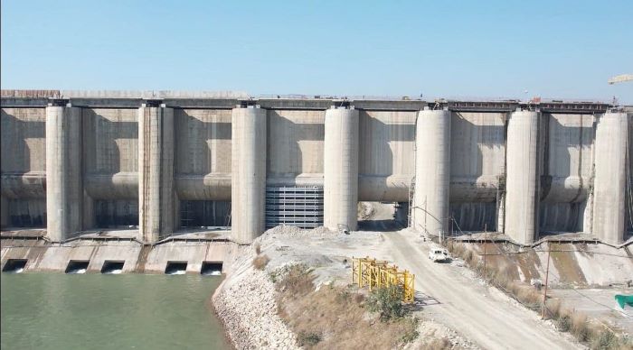
Shahpur Kandi Dam on Ravi
The operation of the Ranjit Sagar Dam (RSD) and the Shahpur Kandi Dam (SKD) lies entirely within the purview of the Punjab Irrigation Department—unlike the Bhakra and Pong dams, which are run by the Bhakra Beas Management Board (BBMB), an inter-state body that in theory represents partner states but in practice functions under the effective control of the Central Government. Against this backdrop, opposition politicians in Punjab have often asked whether the floodgates of RSD were opened too late or in a manner that aggravated flooding. These are political questions, posed for accountability in public life, but they are rarely anchored in the technical or hydrological realities of dam operation. It is important to distinguish political debate from engineering fact. What follows is not about blame; it is a search for clarity through the lens of hydrology, dam safety, gate management, and public transparency.
The Shahpur Kandi Project today
The Shahpur Kandi Dam (SKD) is structurally complete and edging toward full operation. Designed as a balancing reservoir between the upstream Ranjit Sagar Dam and the downstream Madhopur Headworks, SKD’s job is to smooth power peaking and stabilise canal supplies; it is not a flood-cushioning reservoir. The site lies ~11 km below RSD and ~8 km above Madhopur, with two powerhouses, live storage of about 9.7 million cubic metres, and a full-reservoir level in the 401–404.5 m band. Civil works were completed in early 2024 after decades of delay; commissioning of the power component has been targeted for mid-September 2025, subject to safety clearances.
Is Shahpur Kandi fully “live”?
Even after completion, SKD is not yet functioning at full capacity. Jammu & Kashmir’s entitlement of 1,150 cusecs is pending because pondage has not reached the authorised level and Dam Safety Act compliance is still being closed out. In this first-fill period, impoundment has necessarily been conservative. SKD has therefore been operated cautiously, passing most inflows rather than storing aggressively.
Three pieces of material shared here reset the emphasis of any fair analysis:
The schematic line diagram places the Ujh confluence ~20 km downstream of Madhopur. SKD lies ~8 km upstream of Madhopur; RSD is ~11 km upstream of SKD.
The departmental table of khads/nallahs between RSD and Madhopur lists an aggregate discharge on the order of one lakh cusecs (≈100,200), distributed across minor tributaries such as Sukhal, Basantpur, Bhatindi, Barni, Kiala, Dhanna, Binaat, Dhanot, Kardoh and a few smaller nallahs.
The index plan corroborates these placements, showing numerous khads fanning across the landscape, but either joining below Madhopur or adding modest flows above it.
These three facts have a direct consequence: the Ujh and other downstream tributaries could not have contributed to the peak measured at the Madhopur Headworks, and the small khads that do enter above Madhopur provide only a limited increment to whatever RSD passes.
The August 2025 floods—reframed
Because the Ujh joins below the barrage, it could not have contributed to the peak discharge recorded at Madhopur. Likewise, the khads/nallahs listed between RSD and Madhopur, even taken together, account for ~1 lakh cusecs, which is significant but not of the same order as the multi-lakh peaks reported at the barrage during the crisis window. It follows that the Madhopur hydrograph for 26–27 August must have been driven primarily by the release pattern from RSD, with only a modest increment from the listed khads.
Put plainly: if Madhopur saw a sudden, high-magnitude surge at the very time its gates failed, that surge cannot be attributed to the Ujh or to tributaries below the headworks. The most plausible hydrological explanation is a sequence at RSD that combined (i) insufficient pre-monsoon drawdown, (ii) delayed or inadequate early releases as inflows began to climb, and then (iii) a rapid ramp-up—a “panic opening”—to protect the dam as reservoir level approached the red line. Such a pattern would produce a steep rising limb that a downstream barrage not engineered for fast, large changes in head may be unable to pass safely—especially if its own gate management (inspection, lubrication, hoist capacity, synchronisation, and operator readiness) was less than ideal.
This reframing does not accuse individuals. It only aligns the observed outcome with the basin geometry now established: Ujh is downstream of Madhopur; khads above Madhopur are limited; therefore, RSD releases dominate the hydrograph at the headworks.
Why Shahpur Kandi could not “soak up” the wave
Some ask why SKD did not cushion the flood. The answer lies in first principles:
Purpose and scale. SKD’s live storage (≈9.7 MCM) equals <1 hour of flow at 1,00,000 cusecs, and ~½ hour at 2,00,000 cusecs. It was never designed as a monsoon sponge.
Proximity and first-fill limits. Being only 11 km below RSD, SKD has almost no travel-time to reshape a surge; during first-fill and pending final safety sign-offs, operators are obliged to pass most inflow.
Geometry. With the Ujh below Madhopur, there is no “downstream tributary cushion” for SKD to intercept. By design, SKD’s hydraulic influence on the Madhopur peak is minimal.
So where did the water at Madhopur come from?
From RSD’s gated releases, primarily. The departmental table suggests the incremental capacity of the khads above Madhopur is around one lakh cusecs. That alone cannot explain a multi-lakh peak. If the observed peak at Madhopur exceeded that order of magnitude by a factor of two, three or more, the balance must have been passed through RSD. This is consistent with field accounts of a sudden acceleration in flow during the critical hours, the kind of step change associated with rapid gate opening upstream.
Gate management and coordination
None of this is said to assign guilt; it is a call for systems discipline. The material points toward a coordination gap across three control points—RSD (large storage with gated outlets), SKD (balancing structure), and Madhopur (barrage gates). When a basin is run as a chain, gate management must be synchronised across all links:
Rule-curves and pre-monsoon drawdown targets at RSD should be explicit, published, and audited.
Ramping limits (maximum rate-of-change of discharge) should be enforced to avoid shock-loading Madhopur.
Shared telemetry and a single incident commander should bind RSD, SKD and Madhopur during alerts, with hour-by-hour logs of level–inflow–outflow–gate opening states preserved and disclosed after the event.
Madhopur gate health—inspection, lubrication, hoist tests, and contingency procedures—must be maintained to a standard that assumes fast-rising flows will occur.
Safety and commissioning
There is no evidence at present of damage to the SKD dam body or to its two powerhouses. The project should proceed to commissioning once the safety checklist is complete. But the flood has revealed the need for a tighter operating doctrine on the Ravi: shared situational awareness, stricter ramping discipline, and pre-agreed Emergency Action Plans that bind the three assets to act as one system.
Key technical questions for the record
Rule-curve and drawdown: What were the target pre-monsoon levels at RSD, and were they achieved on schedule?
Logs and ramp rates: Please publish the 15-minute logs of level–inflow–outflow–gate openings at RSD for 20–31 August, and the ramp-rate limits applied to each gate.
Madhopur gate management: What was the gate-by-gate condition prior to failure, and what does the root-cause analysis say about structural/operational weaknesses?
SKD first-fill constraints: What limits (if any) did Dam Safety Act compliance place on SKD impoundment during the event window?
Tributary accounting above Madhopur: Using the departmental table, what fraction of the Madhopur peak can be attributed to the khads above the barrage, and what residual must therefore have come from RSD?
Protocols and command: What coordination protocol integrates RSD, SKD and Madhopur during flood alerts, and who serves as incident commander?
Forecast support: When forecasts diverged from reality, what fallback meteorology and upstream telemetry guided decisions at RSD, and how did those inputs flow to the Madhopur gatehouse in real time?
A constructive way forward
The new material clarifies the hydraulics of the reach: the Ujh is below Madhopur; the khads above it are limited; therefore the Madhopur peak must be understood primarily as a function of RSD’s release strategy. The lesson is not to wage a political blame-game, but to insist on data transparency, disciplined gate management, and a single chain of command. Shahpur Kandi will still deliver its promised value—peaking optimisation, steadier canals, and the conservation of Ravi waters—once it is fully live and safely integrated into a whole-of-river operating plan.
And as we conclude, a reminder: political narratives will always search for intent and fault. The durable answers, however, lie in engineering data, hydrological fact, and transparent governance. Only by bridging that divide can Punjab move from suspicion to confidence in its water infrastructure—and prevent a repeat of the Madhopur surge that a coordinated system should have managed without catastrophe.